| Africa's Geography |
 first what is the africa Africa?: Africa is the second-largest of the seven continents on Earth (Asia is the largest continent). Africa is bounded by the Atlantic Ocean on the west, the Indian Ocean on the east, the Mediterranean Sea on the north, and the Red Sea on the northeast.
Africa covers 11,700,000 square miles (30,300,000 square kilometers).
Countries: There are about 53 countries in Africa (some countries are disputed). The biggest country in Africa is Sudan, which covers 967,500 square miles (2,505,816 square kilometers). The countries with the largest populations in Africa are Nigeria (107,000,000 people), Egypt (64,800,000 people), and Ethiopia (58,700,000 people).
Highest and Lowest Points: The tallest point in Africa is Mt. Kilimanjaro, in Tanzania (eastern Africa). Mt. Kilimanjaro is 19,340 feet (5895 meters) tall. Africa has no long mountain chains.
The lowest pont in Africa is Lake Assal, in Djibouti (in eastern Africa near the Horn of Africa); it is 512 feet (156 meters) below sea level.
Lakes: Africa's largest lake is Lake Victoria; it covers 26,836 square miles (69,500 square kilometers). Other large lakes in Africa are Lake Tanganyika, Lake Malawi, and Lake Chad.
Rivers: The longest river in Africa is the Nile River; it is 4,241 miles (6825 kilometers) long. Other long rivers in Africa include the Congo River, the Niger River and the Zambezi River.
Deserts: Africa has many vast deserts, including the largest hot desert in the world, the Sahara. The Sahara Desert is located in northern Africa and covers 3,500,000 square miles (9,065,000 square kilometers). The Kalahari, in southern Africa, is another large desert.
Islands: The biggest island off Africa is Madagascar, which is near the coast of southeast Africa. Madagascar covers 226,658 square miles (587,000 square kilometers). Other islands include the Seychelles (a chain of islands north of Madagascar), the Comoros (another chain of islands north of Madagascar), the Canary Islands (a chain of islands off the northwest coast), the Madeira Islands (another chain of islands off the northwest coast), the Cape Verde Islands (off the coast of western Africa), Equatorial Guinea (off the coast of Cameroon), and Sao Tome (southwest of Equatorial Guinea).
www.newtechnology.synthasite.com by: mohamed hassan ibrahim
i change the above lesson to arcabi أولا ما هي افريقيا أفريقيا؟ : أفريقيا هي ثاني أكبر من على الأرض سبع قارات (آسيا هي أكبر قارة). تحده افريقيا على المحيط الأطلسي على الغرب ، والمحيط الهندي في الشرق ، وعلى البحر الأبيض المتوسط في الشمال ، والبحر الأحمر على شمال شرق البلاد. ويغطي افريقيا 11700000 ميل مربع (30300000 كيلومتر مربع). البلدان : هناك حوالي 53 بلدا في أفريقيا (المتنازع عليها بعض البلدان). أكبر دولة في افريقيا والسودان ، والذي يغطي 967500 ميلا مربعا (2505816 كيلومتر مربع). البلدان التي لديها أكبر من السكان في افريقيا هي نيجيريا (107000000 نسمة) ، ومصر (64800000 نسمة) ، وإثيوبيا (58700000 نسمة). أعلى وأدنى النقاط : نقطة أعلى جبل في افريقيا. كليمنجارو ، وتنزانيا (شرق افريقيا). جبل. كليمنجارو هو 19.340 قدم (5895 متر) وطوله. افريقيا ليست طويلة السلاسل الجبلية. أدنى بونت في افريقيا بحيرة عسل ، وجيبوتي) في شرق افريقيا بالقرب من القرن الافريقي) ، بل هوومن 512 قدم (156 متر) تحت مستوى سطح البحر. البحيرات : افريقيا اكبر بحيرة فى بحيرة فيكتوريا ، وهي تغطي مساحة 26836 ميل (69500 كيلومتر مربع). البحيرات الكبرى الأخرى في أفريقيا بحيرة تنجانيقا ، بحيرة ملاوي ، وبحيرة تشاد. الأنهار : اطول نهر في افريقيا هو نهر النيل ، ومن 4241 ميل (6825 كم) لفترة طويلة. طويلة الأنهار الأخرى في أفريقيا وتشمل نهر الكونغو ، والنيجر ، ونهر نهر زامبيزي. الصحراء : أفريقيا الكثير من الصحاري الشاسعة ، وعلى رأسها أكبر الصحراوية الساخنة في العالم ، والصحراء الكبرى. الصحراء الكبرى وتقع في شمال افريقيا ، ويغطي 3500000 ميل مربع (9065000 كيلومتر مربع). كالاهاري في جنوب أفريقيا ، وآخر في الصحراء الكبرى. الجزر : وأكبر جزيرة قبالة أفريقيا ومدغشقر ، والتي تقع بالقرب من ساحل جنوب شرق أفريقيا. مدغشقر يغطي 226658 ميلا مربعا (587000 كيلومتر مربع). الجزر الأخرى تشمل سيشيل (سلسلة من الجزر في شمال مدغشقر) ، وجزر القمر (آخر سلسلة الجزر شمال مدغشقر) ، وجزر الكناري (في سلسلة من الجزر الواقعة قبالة الساحل الشمالي الغربي) ، وجزر ماديرا (آخر سلسلة الجزر الواقعة قبالة الساحل الشمالي الغربي) ، وجزر الرأس الأخضر) قبالة ساحل غرب افريقيا) ، وغينيا الاستوائية (قبالة ساحل الكاميرون) ، وسان تومي (الى الجنوب الغربي من غينيا الاستوائية
بقلم : محمد حسن ابراهيم
In 1974, as young college graduates, Mark and Delia Owens decided that they could not wait to obtain financial security before beginning their careers as field zoologists. So, after auctioning off their possessions, they headed to Africa with one-way air tickets, backpacks and $6,000--to establish a research project in the Central Kalahari Game Reserve in Botswana.
With their meager funds, Delia and Mark purchased a third-hand Land Rover, some basic camping equipment and supplies, and headed off into a 100,000-square-mile void on the map of Botswana. There were no roads, no towns, and only a few bands of native bushmen in the Central Kalahari Game Reserve. After a grueling reconnaissance through one of the most remote deserts of the world, Mark and Delia eventually settled in a tree island in Deception Valley, more than eight hours from the nearest outpost of civilization. In ancient times, the Kalahari was defined by rivers, whose dry channels remain today, bordered by slightly elevated sand dunes. Deception Valley is located on one of these ancient river beds.
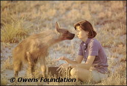 |
| Delia Owens greets the brown hyena "Pepper." |
For seven years, Delia and Mark lived in tents, and studied a pristine wilderness and its inhabitants. They did landmark research on black-maned Kalahari lions and the elusive brown hyena. They survived violent storms, wildfires and 120-degree heat while conducting their research. They chronicled their findings in their book cry of the kalahari and in a series of articles in popular and scientific publications such as Natural History (Feb 1980), International Wildlife (Sept-Oct 1983), Life (Nov. 1984), and Nature (April26/May 2, 1984).
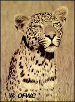 |
| The leopard named "Pink Panther." |
Their life in the Kalahari was rewarding but dangerous. In the end, it was their dedication and love of the place and its wildlife that dictated that they must leave. The Kalahari was hit hard by the African drought of the late 70s and early 80s and dried into miles of dusty badlands. While flying aerial reconnaissance during this period, Mark spotted one of the largest wildebeest migrations ever recorded. The wildebeest were pushing north toward natural water sources that had been available for thousands of years during extreme drought. However, this time, their way was blocked by long veterinary cordon fences erected by the government to separate wild ungulates from domestic stock. Officials believed erroneously that the wild animals would infect cattle with 'hoof-and-mouth disease'. It is now known that the wildlife of the Kalahari had never been infected with the disease, but a quarter of a million wildebeest died along these ill conceived fences. When Mark and Delia could not convince Botswana officials to remove the fences, they exposed this environmental disaster through publications in international journals. In the end, the Botswana government accepted most of the recommendations that Mark and Delia made to conserve the Kalahari, and resolved to maintain the Central Kalahari as a wildlife protectorate. In 1986, before beginning their new research and conservation project in the North Luangwa National Park of Zambia (See north luwangua project ), Mark and Delia returned to the Central Kalahari of Botswana and found the lions and brown hyenas that they had studied for many years.
| www.newtechnology.synthasite.com . |
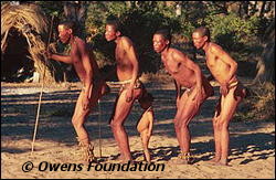 |
| bushmen of kalahari |
bushmen of kalahari
During their seven years of working for conservation in the Kalahari Desert of Botswana, Delia and Mark Owens were greatly impressed with the Bushmen who live in this vast, harsh wilderness. Delia and Mark believe that the San belong to the Kalahari and should be allowed to continue their hunter-gatherer lifestyle in harmony with the natural balance of the Kalahari.
However, should any members of the Bushmen decide to alter their lifestyle to include agriculture and the raising of livestock, it would be destructive to the fragile ecological balance of this protected wilderness area. Delia and Mark believe that Bushmen wishing to raise crops and livestock should be allowed to live on the lands surrounding the Central Kalahari Game Reserve where their activities will not endanger the survival of the plants, animals and people that currently live within the Reserve in harmony.
Delia and Mark hope that the Bushmen will continue their amazing hunter-gatherer lineage as an inspiring part of the Kalahari ecosystem.
في عام 1974 ، كما من الشباب خريجي الجامعات ، ومارك وديليا أوينز وقررت أنها لا تستطيع الانتظار للحصول على الضمان المالي قبل بداية حياتهم المهنية الميدانية العلماء الحيوانيون. لذا ، وبعد للبيع في مزاد وممتلكاتهم ، وكانوا متوجهين الى افريقيا في اتجاه واحد مع تذاكر الطيران ، وعلى الظهر ، ومبلغ 6000 -- لإنشاء مشروع بحثي في وسط محمية كالاهاري في بتسوانا
مع ضآلة الأموال ، ومارك ديليا اشترت من جهة ثالثة لاندروفر ، وبعض المخيمات الأساسية والمعدات واللوازم ، واتجهت الى 100000 ميل مربع الفراغ على خريطة بوتسوانا. عدم وجود الطرق ، وليس المدن ، وعددا قليلا فقط من عصابات الوطنية وسط الادغال في محمية كالاهاري. بعد استطلاع الصعبة من خلال واحدة من أكثر الصحاري النائية من العالم ، ومارك ديليا استقر في النهاية على شجرة في الخداع وادي الجزيرة ، أكثر من ثماني ساعات من أقرب مخفر للحضارة. في العصور القديمة ، كالاهاري حددت الأنهار ، التي لا تزال جافة قنوات اليوم ، تحدها الكثبان الرملية المرتفعة قليلا. الخداع وادي يقع على واحدة من هذه الأنهار القديمة سريرا.لمدة سبع سنوات ، ومارك ديليا يعيشون في الخيام ، ودراسة الحياة البرية البكر وسكانها. لم معلما البحوث السوداء لديه عرف كالاهاري الاسود والبني ضبع بعيد المنال. نجا من العواصف العنيفة وحرائق الغابات و120 درجة الحرارة أثناء إجراء هذا البحث. وهي النتائج التي سجلها في الكتاب صرخة وكالاهاري في سلسلة من المقالات في منشورات علمية وشعبية ، مثل التاريخ الطبيعي (فبراير 1980) ، والاتحاد الدولي للحياة البرية (سبتمبر تشرين الأول / أكتوبر 1983) ، الحياة (نوفمبر 1984) ، والطبيعة ( April26/May 2 ، 1984).
حياتهم في كالاهاري يكافئ لكنه خطير. في النهاية ، كان تفانيهم والحب للمكان والحياة البرية التي تفرض عليهم مغادرة. كالاهاري وكانت ضربة قوية بسبب الجفاف في أفريقيا في وقت متأخر من 70s وأوائل 80s والجافة والمغبرة إلى أميال من الأراضي الوعرة. في حين حلقت الاستطلاع الجوي خلال هذه الفترة ، رصدت مارك واحد من أكبر الحيوانات البرية الهجرات تم تسجيله حتى الآن. فإن الحيوانات البرية تتوغل شمالا نحو مصادر المياه الطبيعية التي كانت متاحة لآلاف السنين خلال الجفاف الشديد. ومع ذلك ، هذه المرة ، وكانت في طريقها الطويل سدت البيطرية الطوق والأسوار التي أقامتها الحكومة لفصل ungulates البرية من الأوراق المالية المحلية. ويعتقد مسؤولو خطأ أن الحيوانات البرية من شأنه أن يصيب الماشية مع 'حافي والفم
مرض '. ومن المعروف الآن أن الحياة البرية من كالاهاري لم مصابين بالمرض ، ولكن من ربع مليون وقتل الحيوانات البرية على طول هذه الأسوار خاطئ. مارك ديليا وعندما لا تستطيع ان تقنع المسؤولين في بوتسوانا لازالة الاسوار ، فإنهم يتعرضون لهذه الكارثة البيئية من خلال المنشورات في مجلات دولية. في النهاية ، حكومة بوتسوانا قبل معظم التوصيات التي ومارك ديليا لحفظ كالاهاري ، والعزم على المحافظة الوسطى كالاهاري باعتبارها محمية الحياة البرية. في عام 1986 ، قبل البدء في البحث عن الجديد والمحافظة على هذا المشروع في الشمال Luangwa حديقة زامبيا (انظر المشروع luwangua شمال) ومارك ديليا وعادت إلى وسط كالاهاري في بوتسوانا وجدت الاسود والبني الضباع أنها درست لسنوات
عديدة .